My kiddos are in the Why and How stages of life. Asking great questions that spark my own curiosity to dig a little deeper than just a surface level understanding.
The latest How was, “How do storms happen?” Which led me down this current rabbit hole of diving a little deeper on how and why we have this crazy weather in the Midwest.
The Setup
The Rocky Mountains play a key role in setting the stage for severe weather in the Midwest, here’s the breakdown:
- Air Mass Clash: The Midwest experiences a battle between two contrasting air masses:
- Warm, Moist Air: This air originates in the Gulf of Mexico, carrying lots of moisture and heat.
- Cold, Dry Air: This air comes from the west, often pushed over the Rocky Mountains. The mountains act as a barrier, forcing the air to rise and cool down, drying it out in the process.
- Lifting and Instability: As the cool, dry air from the Rockies travels eastward, it encounters the warm, moist air mass over the Midwest. This warm air is less dense and wants to rise. The rising warm air creates instability in the atmosphere, a key ingredient for storm formation.
- Fueling the Storm: The rising warm air cools and condenses, forming clouds. The abundant moisture from the Gulf of Mexico provides the “fuel” for these storms to grow tall and powerful.
- Energy from Wind Shear: Wind shear, the change in wind speed or direction with height, plays a crucial role in severe weather. The Rocky Mountains can sometimes influence the jet stream, a fast-moving current of air high in the atmosphere. This jet stream can create strong wind shear, which can further energize the storms and lead to conditions that favor tornadoes, hail, and damaging winds.
So, while the storms don’t originate directly in the Rockies, the mountains play a part in shaping the air masses that collide and create the unstable atmosphere that fuels severe weather in the Midwest.

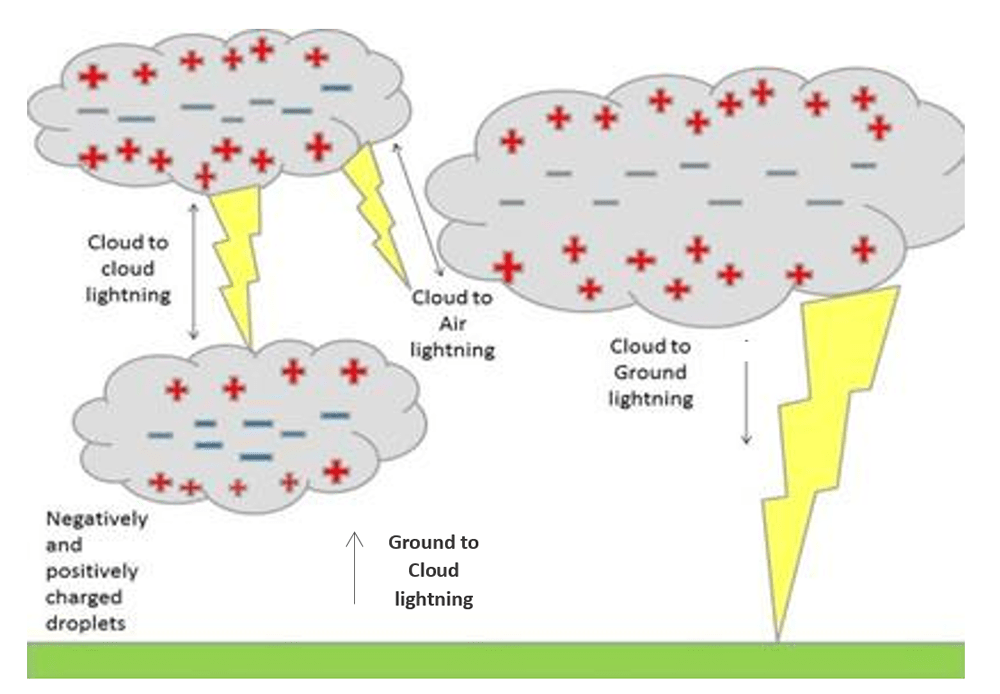
Sparks Fly: Lightning
A giant spark of electricity jumps between clouds, within a cloud, or between a cloud and the ground. Here’s the breakdown of how it forms:
- Charge Separation: Inside a thunderstorm cloud, updrafts and collisions between ice crystals and water droplets create static charges. Generally, the upper part of the cloud becomes positively charged, while the lower part becomes negatively charged.
- Air as Insulator: Normally, air acts as an insulator, preventing the charges from simply discharging. However, as the storm intensifies, the charge separation gets stronger.
- The Stepped Leader: When the charge separation gets strong enough, a channel of negative charge, called a stepped leader, shoots out from the bottom of the cloud towards the ground in a series of branching steps.
- Positive Charge Attraction: The strong negative charge in the stepped leader attracts positive charges in the ground, which surge up towards the leader.
- The Return Stroke: Once a connection is made, a powerful surge of electricity, called the return stroke, travels back down the channel from the cloud to the ground, creating the bright flash of lightning we see.
This entire process happens incredibly fast, taking just milliseconds! The rapid movement of electricity heats the air in the channel to extremely high temperatures, causing it to expand rapidly and creating the loud crack of thunder we hear after the lightning flash.
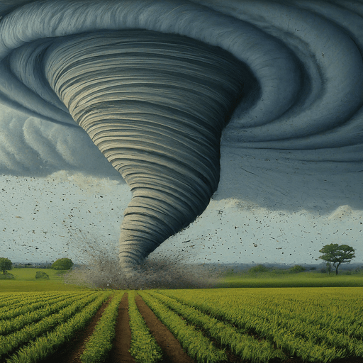
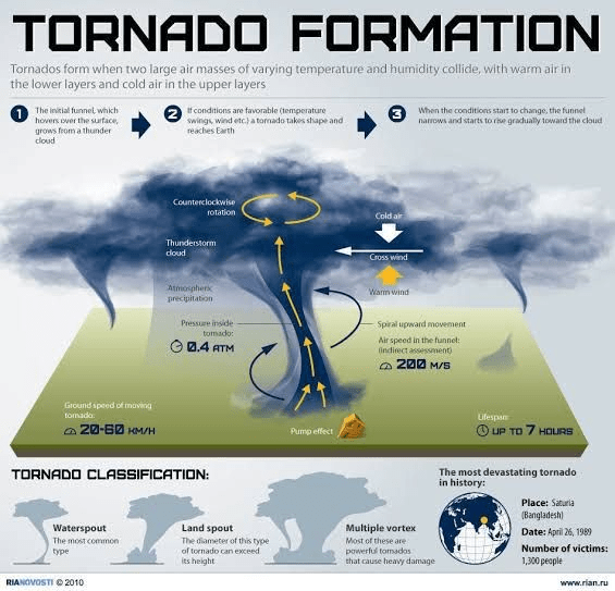
The Scary Stuff: Tornados
There is a unique combination of factors that create ideal conditions for these storms to develop. Here’s a breakdown of the key ingredients:
- Warm, moist air: Warm air near the ground, often originating from the Gulf of Mexico, provides the energy for updrafts – rising air currents that fuel thunderstorms.
- Cool, dry air aloft: Colliding with the warm air mass, cooler air from the north creates instability in the atmosphere, making the warm air rise even faster.
- Wind shear: This is the change in wind speed and direction with height. The jet stream, a fast-moving air current high in the atmosphere, can cause significant wind shear, which acts like a giant blender, twisting and stretching the rising air in the thunderstorm.
These ingredients come together most frequently in the spring and summer months, creating the perfect environment for the formation of supercell thunderstorms – the most potent tornado producers. As warm, moist air rises rapidly in a supercell, the wind shear creates a horizontal spinning motion. This rotation gets stretched and intensified within the storm, eventually forming a narrow, rotating funnel that extends down to the ground – a tornado.
The Aftermath: Rainbows
After all the loud noises, high winds and dark skies, if your lucky, a Rainbow can appear.
Rainbows are a beautiful display of nature’s light show, and they form thanks to the interplay of sunlight and water droplets. Here’s the science behind them:
- Refraction and Separation: Sunlight isn’t just one color, it’s a spectrum of colors with different wavelengths. When sunlight enters a water droplet, it bends (refracts) because it slows down as it travels from air to the denser water. As it bends, the light also separates into its colors – red having the longest wavelength bends the least, while violet with the shortest wavelength bends the most.
- Reflection and Dispersion: Inside the droplet, the separated colors bounce off the back surface. This reflection further separates the colors even more.
- Exiting the Raindrop: Not all the light that enters the droplet exits. Some is absorbed by the water. But the light that manages to escape comes out at a specific angle, depending on the color. Red light exits at a larger angle compared to violet.
- Seeing the Rainbow: An observer positioned at the right angle relative to the sun and the rain will see the separated colors as a full circle or arc in the sky, with red on the outside and violet on the inside – forming the beautiful rainbow!
It’s important to remember that a rainbow isn’t a physical object in the sky, but rather an optical phenomenon caused by the way sunlight interacts with water droplets. You’ll only see a rainbow if you’re positioned at the right angle to the sun and the rain!

Stay dry out there!
